
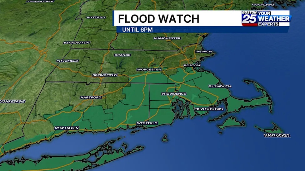
A substantial portion of southern New England is bracing for potentially hazardous weather conditions as meteorological authorities maintain an active flood watch across Massachusetts. The alert was issued in response to incoming rounds of torrential rain and embedded thunderstorms capable of causing rapid runoff and localized flash flooding throughout the remainder of the day.
The flood watch spans several key regions and major population centers across the Commonwealth. In Massachusetts, the alert encompasses eight distinct counties: Bristol, Plymouth, Barnstable, Dukes, Nantucket, Worcester, Norfolk, and Suffolk. Emergency managers and weather forecasters have advised that the watch will remain in effect through 6 p.m. on Sunday as heavy rain bands track across the state.
The geographic footprint of the highest threat is concentrated primarily along and to the south of the Massachusetts Turnpike. Residents and travelers throughout these southern and eastern corridors are being warned to remain alert for rapidly deteriorating road conditions and pooling water as the storm cluster advances through the region.
According to Boston 25 meteorologist A.J. Mastrangelo, the primary concentration of severe precipitation was slated to push into southeastern Massachusetts through the late morning hours. Forecasters highlighted that the meteorological dynamics favor persistent downpours along the southern half of the state, sustaining the active flood watch through its late-afternoon expiration time.
The atmospheric setup driving this weather event involves widespread showers intermixed with embedded thunderstorms. These convective cells are capable of generating narrow, highly focused bands of torrential downpours that can drop large quantities of water over localized areas in very short periods of time.
In terms of anticipated precipitation totals, widespread rainfall across the watch zone is projected to reach between half an inch and two inches. While these general amounts are manageable for many areas, the primary concern stems from the high-intensity bands forming within the broader storm system.
Forecasters have warned that within those isolated, narrower bands of intense precipitation, rainfall totals could rapidly climb between 2 and 4 inches within just a three-hour timeframe. Such dramatic accumulation rates significantly elevate the potential for sudden water rises, overwhelming municipal drainage networks and causing flash flooding.
The National Weather Service issued a detailed assessment of the looming hazard, emphasizing the localized nature of the most extreme rainfall. While forecasters acknowledged that there remains uncertainty regarding precisely where these narrow ribbons of heaviest rain will set up, the threat of flash flooding remains acute wherever they stall or track repeatedly.
Urban centers are considered especially susceptible to these sudden downpours. The National Weather Service highlighted that should these narrow corridors of intense rain develop directly over vulnerable metropolitan environments, the high concentration of paved surfaces could lead to rapid flooding on city streets, underpasses, and low-lying infrastructure.
Because of the potential for severe disruption and water-related hazards, the Boston 25 Weather Team placed the region on a Severe Weather Alert. The alert is intended to ensure that communities across southern New England remain vigilant as atmospheric conditions evolve and storm cells move across the area.
In addition to potential road flooding, heavy rain and thunderstorm activity carry the risk of localized power disruptions. State emergency officials are reminding the public to track utility impacts using real-time resources. The Massachusetts Emergency Management Agency (MEMA) provides a dedicated power outage viewer that tracks current utility outages across individual communities, broader regions, and the entire state, offering estimated restoration times provided by local electric companies.
Residents are also encouraged to utilize MEMA's live weather radar and forecasting resources to follow storm tracks in real time. These digital tools allow residents to monitor the progress of heavy rain bands as they traverse specific neighborhoods and travel corridors.
For individuals requiring community assistance or non-emergency support during severe weather events, state resources such as Mass211 are available to provide localized guidance and information. Additional coordination and safety oversight remain supported by federal and regional agencies, including the Federal Emergency Management Agency (FEMA).
Meteorologists with both the Boston and Albany, New York, offices of the National Weather Service, alongside local broadcast meteorologists, continue to monitor atmospheric conditions closely. With the flood watch scheduled to continue through 6 p.m. on Sunday, residents across Worcester, Norfolk, Suffolk, Bristol, Plymouth, Barnstable, Dukes, and Nantucket counties are urged to remain cautious, avoid flooded roadways, and stay informed through official weather updates.





(0)